Fire Danger Index (FDI) Regional Matrices

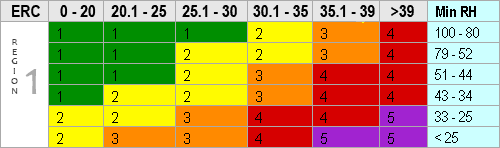
Florida Forest Service- REGION 1: The Panhandle
COUNTIES: Bay, Calhoun, Escambia, Franklin, Gadsden, Gulf, Holmes, Jackson, Jefferson, Leon, Liberty, Okaloosa, Santa Rosa, Wakulla, Walton, Washington
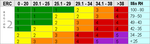
Florida Forest Service- REGION 2: North Florida
COUNTIES: Alachua, Baker, Bradford, Clay, Columbia, Dixie, Duval, Flagler, Gilchrist, Hamilton, Lafayette, Levy, Madison, Marion, Nassau, Putnam, St. Johns, Suwannee, Taylor, Union, Volusia
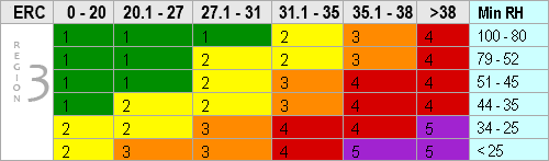
Florida Forest Service- REGION 3: Central Florida
COUNTIES: Brevard, Citrus, Flagler, Hernando, Hillsborough, Lake, Orange, Osceola, Pasco, Pinellas, Polk, Seminole, Sumter
NOTE: With help from experienced local personnel in the field, three counties (Flagler, St. Johns, and Volusia) have been moved to Region 2 to better reflect fire behavior in the region.
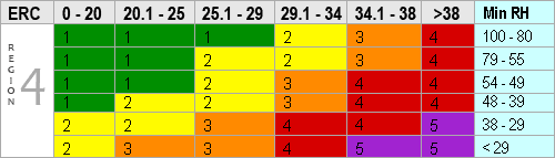
Florida Forest Service- REGION 4: South Florida
COUNTIES: Broward, Charlotte, Collier, Desoto, Glades, Hardee, Hendry, Highlands, Indian River, Lee, Manatee, Martin, Miami-Dade, Monroe, Okeechobee, Palm Beach, Sarasota, St. Lucie
NOTE: With help from experienced local personnel in the field, the matrix for Region 4 has been changed slightly to better reflect fire behavior in the region.