Program Resources
LandScope: Disappearing Landscapes
Longleaf Natural Community Descriptions
Web Map
Contact Us
For program questions and data license agreements:
Mark Kiser
State Forest Ecologist
(850) 681-5885
Mark.Kiser@FDACS.gov
Florida Department of Agriculture and Consumer Services
Florida Forest Service
Forest Management Bureau
For technical data questions:
Amy Knight
Florida Natural Areas Inventory
GIS Program Specialist
(850) 224-8207 ext. 214
aknight@fnai.fsu.edu
The Florida Longleaf Pine Ecosystem Geodatabase
The Florida Forest Service and the Florida Natural Areas Inventory have partnered to develop the Longleaf Pine Ecosystem Geodatabase (LPEGDB). This spatial database serves as the central repository for data on the distribution and ecological condition of longleaf pine ecosystems in Florida. The database includes data provided by many partner agencies and organizations as well as new field assessment data collected for this project.
The Longleaf Pine Ecosystem Geodatabase represents a major step toward fulfilling both inventory and assessment objectives of
Florida’s Forest Action Plan
[
 11.5 MB
]
and America’s Longleaf 2009 Range-Wide Conservation Plan for Longleaf Pine[ ]. Ultimately, it will provide guidance on where and how to accomplish goals for conservation, restoration and management of longleaf pine ecosystems. As funding allows, the Florida Forest Service and Florida Natural Areas Inventory will continue to enhance, improve, and update the database, along with related tools and maps.
11.5 MB
]
and America’s Longleaf 2009 Range-Wide Conservation Plan for Longleaf Pine[ ]. Ultimately, it will provide guidance on where and how to accomplish goals for conservation, restoration and management of longleaf pine ecosystems. As funding allows, the Florida Forest Service and Florida Natural Areas Inventory will continue to enhance, improve, and update the database, along with related tools and maps.
Why Longleaf Pine Matters
Longleaf pine ecosystems are among the most diverse in North America, supporting a large array of herbs and grasses, as well as rare animal species such as red-cockaded woodpeckers and gopher tortoises. Longleaf pine forests and savannas historically dominated the southeastern coastal plain. However, they were drastically reduced from an estimated 90 million acres to less than 3 million acres, largely due to urbanization, overutilization, conversion to other land uses, and exclusion of natural fire regimes.
Much of the remaining acreage exists as fragmented stands in varying degrees of isolation. Recently, however, many organizations and agencies have taken steps to prevent further loss, improve what’s left, and restore the longleaf pine ecosystem where practicable. The Longleaf Pine Ecosystem Geodatabase contributes to this effort by providing detailed, baseline data on the location and current ecological condition of remaining longleaf sites in Florida.
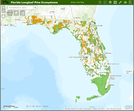
Longleaf Pine Ecosystem Interactive Map
View the Longleaf Pine Ecosystem Interactive Map and interact with map layers related to longleaf pine occurrence and condition.
Current Project Results
- There are 2.36 million acres of longleaf pine ecosystems confirmed in Florida.
- Seventy-three percent (1.72 million acres) is longleaf dominant or co-dominant in canopy.
- Forty percent of mapped longleaf pine (966,000 acres) occurs on private lands.
- Data on ecological condition is available for 72 percent (1.69 million acres) of Florida’s longleaf pine ecosystems.
Versions
LPEGDB v.1, published June 2014. This version corresponds to the LPEGDB Final Report and represents all tasks involved in the initial development of the database, including compilation of potential longleaf pine ecosystems, extensive mining of existing assessment data, and the rapid assessment of more than 800,000 acres of longleaf pine ecosystems by the Florida Forest Service.
LPEGDB v.2, published October 2014. Version 2 fills several remaining data gaps on managed conservation lands, especially gaps in ecological condition of longleaf pine ecosystems. Updates are included for lands managed by the Florida Forest Service, Eglin Air Force Base, U.S. Forest Service, and St. Johns River Water Management District, as well as longleaf plantings on private lands.
LPEGDB, v.3, published September 2015. Version 3 includes updates based on FNAI field projects and several partner data sources. Attributes and summaries for conservation lands and land cover were added and the database format was revised. The Rapid Assessment Data Collection Model was also updated and field data collection tools are available on request.
LPEGDB, v.4, published September 2018. Version 4 includes a major update based on a second phase of rapid assessment by Florida Forest Service county foresters, which focused primarily on planted longleaf. Additional updates were based on new FNAI field projects and updates from partner data sources.
Downloads
-
LPEGDB v.4 Final Report, published September 2018
[
14 MB
]
. This report describes a major update to the LPEGDB, including new rapid assessment data collection, a revised crosswalk of condition data into management levels, and final results.
-
LPEGDB v.3 Summary Report, published September 2015
[
16.1 MB
]
. This report is supplementary to the Final Report. It describes the latest updates to longleaf data, database format, and the Rapid Assessment Data Collection Model. Acreage summaries by manager type, land cover type, and county are included.
-
LPEGDB v.2 Supplement Report, published October 2014
[
953.3 kB
]
-
LPEGDB Final Report, published June 2014
[
5.4 MB
]
. This report describes development of LPEGDB v.1, including database design, rapid assessment protocol, crosswalk of condition data into management levels, and initial results.
-
LPEGDB Data License Agreement
[
94.4 kB
]
Program Resources
LandScope: Disappearing Landscapes
Longleaf Natural Community Descriptions
Web Map
Contact Us
For program questions and data license agreements:
Mark Kiser
State Forest Ecologist
(850) 681-5885
Mark.Kiser@FDACS.gov
Florida Department of Agriculture and Consumer Services
Florida Forest Service
Forest Management Bureau
For technical data questions:
Amy Knight
Florida Natural Areas Inventory
GIS Program Specialist
(850) 224-8207 ext. 214
aknight@fnai.fsu.edu


