Contact Us
(352) 797-4140
Email Withlacoochee State Forest
Florida Forest Service
Withlacoochee State Forest
Visitor Center
15003 Broad St.
Brooksville, FL 34601-4201
Visitor Center Hours: Monday–Friday, except holidays:
8 a.m.–noon & 1 p.m.–4:30 p.m.
Hours may change without notice. Please call ahead if you plan to stop by.
Program Resources
- Current State Forest Management Plans
-
Driving Directions Brochure
[
 258.7 kB
]
258.7 kB
]
-
Four Wheel Drive Know Before You Go Brochure
[
288.3 kB
]
-
History of Withlacoochee State Forest
[
16.7 MB
]
- Photos of Withlacoochee State Forest
- Trailtrotter Program
- Trailwalker Hiking Program
-
Withlacoochee State Forest Brochure
[
970.2 kB
]
-
Withlacoochee State Forest in a Nutshell Brochure
[
625.7 kB
]
-
Withlacoochee State Forest Management Plan
[
696.9 kB
]
Maps:
Smart device mapping is possible and encouraged in the state forests. Before visiting a forest, search for “PDF Maps” in the app store to find an app that works for you and download our state forest map, which is georeferenced.
-
Withlacoochee State Forest Map
[
2 MB
]
-
Annutteliga Hammock Brochure
[
316.2 kB
]
-
Citrus Hiking Trails Brochure
[
738.5 kB
]
-
Citrus Horse Trail Brochure
[
569.6 kB
]
-
Croom River Hiking Tract
[
269 kB
]
-
Croom Tract Hiking Trails
[
361.4 kB
]
-
Croom Horse Trail Brochure
[
979.6 kB
]
-
Croom Motorcycle Area Buttgenbach Mine Campground Brochure
[
799.1 kB
]
-
Croom Off-Road Bicycle Trail Brochure
[
451.5 kB
]
-
Croom River Trail Brochure
[
557.3 kB
]
-
Homosassa Tract
[
365.4 kB
]
-
Homosassa Tract Brochure
[
367 kB
]
-
Little River Multi-Use Trail Brochure
[
334.4 kB
]
-
Little River Multi-Use Trail Map
[
280.2 kB
]
-
McKethan Lake Day Use Area Brochure
[
403.4 kB
]
-
Richloam Hiking Trail Brochure
[
731.3 kB
]
-
Silver Lake Brochure
[
599.6 kB
]
-
Silver Lake Complex
[
224.1 kB
]
-
Two Mile Prairie Brochure
[
968.8 kB
]
-
Two Mile Prairie Tract Map
[
203.5 kB
]
-
Withlacoochee Canoe Trail
[
41.5 kB
]
-
Withlacoochee Croom Hike and Bike Trails
[
636.5 kB
]
-
Annutteliga Hammock Brochure
[

The Florida National Scenic Trail passes through the forest.

Withlacoochee State Forest is part of the Great Florida Birding Trail.
Recreation and Amenities
Trails: Hiking, biking, horse, off-highway vehicle and birding
Recreation Reservations and Fees : Visit State Forest Camping, Day-use and OHV Passes or call 1-877-879-3859.
Water: Boat ramp, canoe launch, dock and fishing
Other:
- Hunting, nature study, restrooms, showers, pavilions, picnic tables, grills, stables and dining halls. Pavilions and dining halls require reservations.
- Leashed pets allowed unless otherwise posted. Contact the visitor center for specific information at (352) 797-4140.
Recreation at Withlacoochee State Forest
Recreation Tracts: Citrus | Headquarters | Homosassa | Jumper Creek | Richloam | Two Mile Prairie | Croom
Withlacoochee State Forest has outstanding forest and water resources that offer a variety of recreational opportunities attracting over 1.1 million visitors annually.
All formal organized group activities, including picnicking, trail use and overnight camping, require a State Forest Use Authorization. To obtain a State Forest Use Authorization, please call the Visitor Center at (352) 797-4140 and we will assist you with your plans.
Citrus Tract
Citrus and Hernando Counties
The Citrus Tract encompasses nearly 50,000 acres and includes three recreation areas with camping. Enjoy camping, hunting, wildlife viewing, hiking, birding, picnicking and horseback riding.
Holder Mine Recreation Area
Citrus County
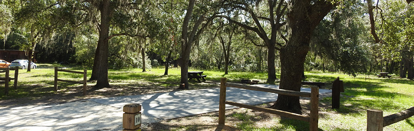
The Holder Mine Campground campsites are shaded by live oaks and turkey oaks. This campground is popular with hunters during archery and small game seasons.
Features
- Camping
- Hiking
- Picnicking
- Leashed pets allowed
Facilities
- Bathhouse
- Campsites with concrete pads, electricity, water, picnic table and fire ring with grate. For camping information and reservations, visit Reserve America or call 1-877-879-3859.
- Dump station
- Limited $5 per night vehicle overflow parking within campground. Additional overflow parking outside campground and south of Trail 10 or Forest Road.
- Pavilion for use by paid campers only. For information and reservations, visit Reserve America or call 1-877-879-3859.
Trails
- Hiking trails
- Citrus A Loop Trail is 8.6 miles.
- Citrus B Loop Trail is 17.3 miles.
Address
- Address: 3049 East Trail 10, Inverness, FL 34452
- GPS Coordinates: 82º 22.958’ W 28º 48.027’ N
Directions
From State Road 44 in Inverness, turn south at the traffic light at Applebee's on Pleasant Grove Road (C-581). Drive approximately 2.5 miles (passing the fire tower) to Forest Road (Trail 10). Turn right (west) on Forest Road (Trail 10) and continue approximately 2 miles to Holder Mine Recreation Area and Campground. Do not attempt to enter the Citrus Tract for the Holder Mine Campground using any other directions or by relying on Google Maps, Google Earth or other mapping resources that provide driving directions that are different than these.
Mutual Mine Recreation Area
Citrus County
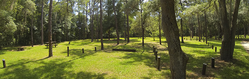
Mutual Mine Campground has campsites in a horseshoe formation next to a picturesque, rain-filled lake that was formerly a mine pit.
Note: This area is for permitted campers only. Parking for trails is located outside the campground.
Features
- Camping
- Hiking
- No alcohol allowed
- No pets allowed
Facilities
- Group camp for organized youth groups requires a reservation. To make a reservation, visit Reserve America or call 1-877-879-3859.
- Primitive campsites with water, picnic table, and fire ring with grate and/or grill. For camping information and reservations, visit Reserve America or call 1-877-879-3859.
- Restroom (no showers)
Trails
- Hiking trails
- Citrus C Loop is 16.9 miles.
- Citrus D Loop is 19.4 miles.
Address
- Address: 4771 East Trail 16, Inverness, FL 34452
- GPS Coordinates: 82º 21.341’ W 28º 45.487’ N
Directions
From State Road 44 in Inverness, turn south at the traffic light at Applebee's on Pleasant Grove Road (C-581). Drive approximately 5 miles to Forest Road (Trail 16). Turn right (west) on Forest Road (Trail 16) and continue 500 feet to entrance to Mutual Mine Campground on left. Access requires gate combination 24 hours per day. Do not attempt to enter the Citrus Tract for the Mutual Mine Campground using any other directions or by relying on Google Maps, Google Earth or other mapping resources that provide driving directions that are different than these.
Tillis Hill Recreation Area
Citrus County
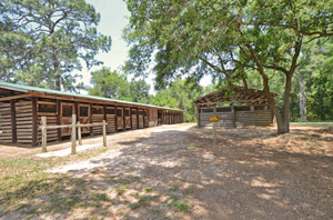
Horse stalls at Tillis Hill
Whether you want a day's ride or a full equestrian camping trip, enjoy riding through some of the most beautiful public lands in Central Florida at Tillis Hill Recreation Area.
The Tillis Hill Day Use Area has a day use fee. Facilities include campsites, dining hall, pavilion and a commercial-sized grill/smoker. All amenities require reservations. To reserve, visit Reserve America or call 1-877-879-3859.
Group activities require a State Forest Use Permit, which can be obtained by calling (352) 797-4140.
Features
- Camping
- Horseback riding
- Picnicking
- No pets allowed
Facilities
- Bathhouses
- Campsites with paved slabs, electricity, water, picnic table, and fire ring with a grate and/or a grill. For camping information and reservations, visit Reserve America or call 1-877-879-3859.
- Commercial BBQ grill/smoker. To reserve, visit Reserve America or call 1-877-879-3859.
- Dining hall/meeting room. To reserve, visit Reserve America or call 1-877-879-3859.
- Dump station
- Thirty-six horse stalls. Two stalls are designed for stallions. A communal corral is also available. For stall information and reservations, visit Reserve America or call 1-877-879-3859.
- Pavilion. To reserve, visit Reserve America or call 1-877-879-3859.
Trails
- Equestrian trails
- One Day Trail is 12 miles.
- Two Day Trail is 24 miles.
Note: ALL horses must have proof of current negative Coggins test results when on state lands. ALL children under the age of 16 are required to wear a protective helmet while riding on state lands.
Address
- Address: 9231 South Trail 13, Inverness, FL 34452
- GPS Coordinates: 82º 24.882’ W 28º 43.700’ N
Directions
From Pleasant Grove Road (C-581), turn (west) on Stage Coach Trail (C-480) and continue approximately 4 miles to Forest Road (Trail 13) and turn right (north). Continue approximately 1.5 miles to the fork in the road and take the right fork up the hill to Tillis Hill Recreation Area and Campground. Do not attempt to enter the Citrus Tract for the Tillis Hills Campground using any other directions or by relying on Google Maps, Google Earth or other mapping resources that provide driving directions that are different than these.
Headquarters Tract
Hernando County
This tract includes recreation at McKethan Lake and Colonel Robins Group Area. The visitor center for Withlacoochee State Forest is also located on this tract.
Visitor Center
Hours
The Visitor Center is open Monday through Friday, except holidays, from 8 a.m.–noon and 1p.m.–4:30 p.m.
Hours may change without notice. Please call ahead at (352) 797-4140 if you plan to stop by.
Address
15003 Broad Street, Brooksville, FL 34601
McKethan Lake Day Use Area
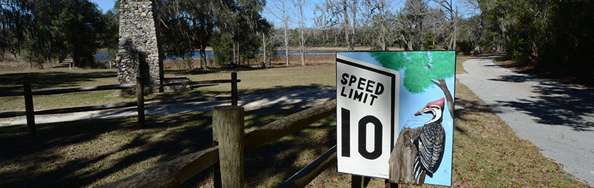
Three pavilions and numerous picnic tables are nestled around the lake. The nature trail offers visitors a chance to view wildlife such as white-tailed deer, hawks and owls. There are four species of southern pine: longleaf, slash, loblolly and sand.
Day-use fee of $2 per person is applicable to all day users, including pavilion users. To pay day-use fee, visit the Web Store at Reserve America on the morning of your visit.
Features
- Fishing
- Hiking
- Picnicking
- No pets allowed
Facilities
- Grills
- Pavilions. For information and reservations, visit Reserve America or call 1-877-879-3859.
- Picnic tables
- Play area
- Restrooms
Trails
- McKethan Lake Nature Trail is 2 miles and included in the Trailwalker program.
Address
15185 Broad St., Brooksville, FL 34601
Colonel Robins Group Area and Primitive Campsite
Colonel Robins gives groups a place to camp surrounded by nature and wildlife.
Features
- Camping
- Hiking
- No pets allowed
Facilities
- Group camp area requires reservations. For camping information and reservations, visit Reserve America or call 1-877-879-3859.
- Hammock campsite accommodating up to five hammocks.
- Picnic tables with lantern hangers
- Restrooms
Trails
- Nature trail
Address
13000 Broad Street, Brooksville, FL 34601
Homosassa Tract
Citrus County
-
Homosassa Tract Map
[
265.7 kB
]
- Homosassa Wildlife Management Area
Features
- Birding
- Hiking
- Wildlife viewing
Trails
- The Rooks Loop Trail is 2.7 miles and is included in the Great Florida Birding and Wildlife Trail.
Directions
The Homosassa Tract office is located on U.S. Highway 19 six miles south of Homosassa Springs at the fire tower and Burnt Bridge Road. Take Burnt Bridge Road for 2 miles west to the end of the road. Park in the lot near the kiosk.
Jumper Creek Tract
Sumter County
The Jumper Creek Tract is located along the east side of the Withlacoochee River in Sumter County. Jumper Creek runs through the center of the area and flows north into the Withlacoochee River.
Features
- Biking
- Canoeing
- Fishing
- Hiking
- Leashed pets allowed
Facilities
- Canoe launch
Trails
- Canoe trail
Richloam Tract
Sumter, Pasco, Lake and Hernando Counties
With over 56,000 acres, the Richloam Tract encompasses pine flatwoods, oak hammocks, bottomland hardwoods and cypress swamp. The Little River parcel, located in the northwest portion, is closed to hunting.
Features
- Hiking
Facilities
- The Cedar Hammock Lodge is available for meetings and special events. Reservations are required and can be made by visiting Reserve America or calling 1-877-879-3859.
Trails
- Multi-use trails for hiking, biking and horseback riding
-
Little River Trail
[
392.8 kB
]
is 8 miles and is included in the Trailtrotter Program.
- The Van Fleet State Trail starts at the Mabel Trailhead.
- Richloam Work Center Trailhead: East Loop is trail 8.6 miles and the North Loop trail is 13.3 miles.
- Richloam Firetower Trailhead: South Loop Trail is 12.4 miles.
-
Little River Trail
[
Note: All horses must have proof of current negative Coggins test results when on state lands. ALL children under the age of 16 are required to wear a protective helmet while riding on state lands.
Revels Pond Day Use Area
Located near the entrance to the Baird Unit on County Road 471.
Features
- Picnicking
- Fishing
- Leashed pets allowed
Two Mile Prairie Tract
Citrus County
Enjoy a variety of natural upland and wetland plant communities including sandhills, scrub, hardwood hammocks and open prairie.
- Two Mile Prairie Recreation Site (Southwest Florida Water Management District)
Bear Head Hammock
Features
- Horseback riding
- Picnicking
Facilities
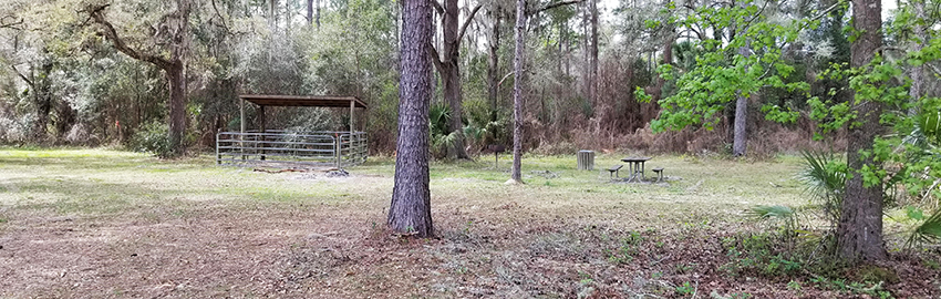
- Primitive campsites with horse stall, picnic table, fire ring and a grill. For camping information and reservations, visit Reserve America or call 1-877-879-3859.
- Restroom (no running water or showers)
Trails
- Equestrian Trail is 8.4 miles and included in the Trailtrotter Program.
Note: All horses must have proof of current negative Coggins test results when on state lands. All children under the age of 16 are required to wear a protective helmet while riding on state lands.
Address
7112 N. Lecanto Highway (C-491), Hernando, FL 34442
Johnson Pond
Features
- Fishing
- Hiking
- Picnicking
Facilities
- Fishing pier
- Picnic shelter
Trails
Address
3042 East Withlacoochee Trail (C-39), Dunnellon, FL 34434
Oxbow
Features
- Canoeing
- Fishing
- Picnicking
Facilities
- Picnic area along the river
- Primitive Camp Zone — paddle in. Reservations required. To reserve, visit Reserve America or call 1-877-879-3859.
Trails
- Hiking Trail Loop is 0.76 miles and included in the Trailwalker Program.
Address
2787 East Withlacoochee Trail (C-39), Dunnellon, FL 34434
Canoe Trails
The Withlacoochee South River flows through the Withlacoochee State Forest. The takeout is at the bridge on U.S. Highway 41 before Lake Rousseau. Distances below are in river miles.
- U.S. Highway 98 bridge to State Road 50/U.S. Highway 98 bridge is 6 miles.
- State Road 50/U.S. Highway 98 bridge to Silver Lake/River Junction is 6 miles.
- Silver Lake/River Junction to County Road 476 bridge at Nobleton is 10 miles.
- Silver Lake/River Junction to Iron Bridge is 3 miles.
- Silver Lake/River Junction to Hog Island is 6.5 miles.
- County Road 476 bridge at Nobleton to County Road 48 bridge is 9 miles.
- County Road 48 bridge to State Road 44 bridge is 14.4 miles.
- County Road 48 bridge to Shell Island. Shell Island to Two Mile Prairie Canoe Camp is 4.5 miles.
Additional Canoe Trail Information
Contact Us
(352) 797-4140
Email Withlacoochee State Forest
Florida Forest Service
Withlacoochee State Forest
Visitor Center
15003 Broad St.
Brooksville, FL 34601-4201
Visitor Center Hours: Monday–Friday, except holidays:
8 a.m.–noon & 1 p.m.–4:30 p.m.
Hours may change without notice. Please call ahead if you plan to stop by.
Program Resources
- Current State Forest Management Plans
-
Driving Directions Brochure
[
258.7 kB
]
-
Four Wheel Drive Know Before You Go Brochure
[
288.3 kB
]
-
History of Withlacoochee State Forest
[
16.7 MB
]
- Photos of Withlacoochee State Forest
- Trailtrotter Program
- Trailwalker Hiking Program
-
Withlacoochee State Forest Brochure
[
970.2 kB
]
-
Withlacoochee State Forest in a Nutshell Brochure
[
625.7 kB
]
-
Withlacoochee State Forest Management Plan
[
696.9 kB
]
Maps:
Smart device mapping is possible and encouraged in the state forests. Before visiting a forest, search for “PDF Maps” in the app store to find an app that works for you and download our state forest map, which is georeferenced.
-
Withlacoochee State Forest Map
[
2 MB
]
-
Annutteliga Hammock Brochure
[
316.2 kB
]
-
Citrus Hiking Trails Brochure
[
738.5 kB
]
-
Citrus Horse Trail Brochure
[
569.6 kB
]
-
Croom River Hiking Tract
[
269 kB
]
-
Croom Tract Hiking Trails
[
361.4 kB
]
-
Croom Horse Trail Brochure
[
979.6 kB
]
-
Croom Motorcycle Area Buttgenbach Mine Campground Brochure
[
799.1 kB
]
-
Croom Off-Road Bicycle Trail Brochure
[
451.5 kB
]
-
Croom River Trail Brochure
[
557.3 kB
]
-
Homosassa Tract
[
365.4 kB
]
-
Homosassa Tract Brochure
[
367 kB
]
-
Little River Multi-Use Trail Brochure
[
334.4 kB
]
-
Little River Multi-Use Trail Map
[
280.2 kB
]
-
McKethan Lake Day Use Area Brochure
[
403.4 kB
]
-
Richloam Hiking Trail Brochure
[
731.3 kB
]
-
Silver Lake Brochure
[
599.6 kB
]
-
Silver Lake Complex
[
224.1 kB
]
-
Two Mile Prairie Brochure
[
968.8 kB
]
-
Two Mile Prairie Tract Map
[
203.5 kB
]
-
Withlacoochee Canoe Trail
[
41.5 kB
]
-
Withlacoochee Croom Hike and Bike Trails
[
636.5 kB
]
-
Annutteliga Hammock Brochure
[
The Florida National Scenic Trail passes through the forest.
Withlacoochee State Forest is part of the Great Florida Birding Trail.
Recreation and Amenities
Trails: Hiking, biking, horse, off-highway vehicle and birding
Recreation Reservations and Fees : Visit State Forest Camping, Day-use and OHV Passes or call 1-877-879-3859.
Water: Boat ramp, canoe launch, dock and fishing
Other:
- Hunting, nature study, restrooms, showers, pavilions, picnic tables, grills, stables and dining halls. Pavilions and dining halls require reservations.
- Leashed pets allowed unless otherwise posted. Contact the visitor center for specific information at (352) 797-4140.


