Plank Road State Forest

Acreage: 10,380
Counties: Jefferson and Leon
Recreation and Amenities
Trails: Hiking, bicycling, horseback riding and nature study can be enjoyed using existing roads and fire lines.
Recreation Reservations and Fees: None
Water: Fishing
Other: Hunting
Program Resources
-
Plank Road State Forest Management Plan
[
 47.1 MB
]
47.1 MB
]
- Plank Road Wildlife Management Area
-
Plank Road State Forest Brochure
[
4.6 MB
]
Maps:
Smart device mapping is possible and encouraged in the state forests. Before visiting a forest, search for “PDF Maps” in the app store to find an app that works for you and download our state forest map, which is georeferenced.
-
Plank Road State Forest Map
[
339.5 kB
]
Contact Us
(850) 597-4504
Email Plank Road State Forest
Florida Forest Service
Plank Road State Forest
8701 Old Plank Rd.
Tallahassee FL 32305
Plank Road State Forest
Plank Road State Forest is one continuous tract of land comprising over 10,000 acres along the upper St. Marks River near Tallahassee, Florida. Its name is derived from the historic wood plank road that was constructed in the mid-1800s with the purpose of transporting cotton and other goods from Newport, Florida, where the St. Marks River ceases to be reasonably navigable, to the Georgia line. Although there are no signs of the original plank road, a paved portion of Old Plank Road makes up part of the forest’s boundary on the west.
The St. Marks River is the dominant feature of Plank Road State Forest and flows from northeast to southwest. The forest's pristine wetlands provide water quality protection for the St. Marks River, an Outstanding Florida Water, and numerous springs, including second magnitude Horn Spring, located on the adjacent Natural Bridge Battlefield Historic State Park, and the first magnitude St. Marks Spring just to the south.
Plank Road State Forest is a Florida Forever project acquired through the Land Acquisition Trust Fund in 2017. It is habitat for an abundance of wildlife and serves as the major part of Upper St. Marks River Corridor, maintaining biodiversity, increasing public recreation opportunities, and protecting water resources within the forest as well as the surrounding area.
Location
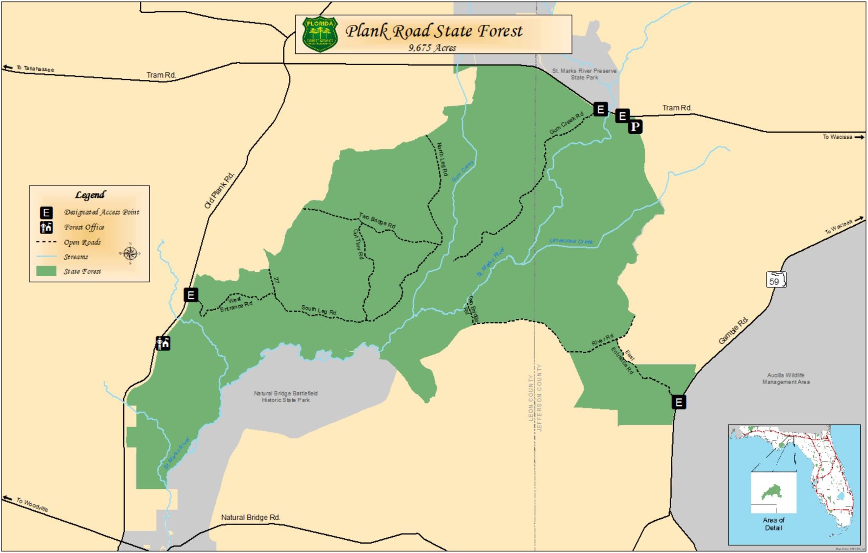
Plank Road State Forest is located along the Upper St. Marks River Corridor between Tram Road on the north and Natural Bridge Road to the south. The forest encompasses eastern Leon County and western Jefferson County, Florida. The state forest headquarters office will be built in the southwest corner of the forest on Old Plank Road, 2.7 miles north of the intersection of Old Plank Road and Natural Bridge Road.
View Large Map
[
339.5 kB
]
Natural Features
The St. Marks River, a designated Outstanding Florida Water, forms on the north and east sides of the forest, while many tributaries, such as Gum Creek, Limestone Creek, Chicken Branch and Hamlin Branch, flow through the forest and into the river.

There are many natural communities within the forest. Among these are floodplain swamp, bottomland forest, sandhill and flatwoods communities. Bald cypress, red maple, swamp tupelo, sweetgum and water oak are commonly found in the floodplain swamps and bottomland forests. Longleaf pine, post oak and turkey oak can be seen in the drier sandhill areas. Flatwoods communities are dominated by gallberry, loblolly pine, slash pine and titi.
Plank Road State Forest is home to many wildlife species, including American alligator, bald eagle, feral hog, Florida black bear, red-shouldered hawk, white-tailed deer and wild turkey.
Recreation
Hunting is the one of the recreational opportunities on Plank Road State Forest. Approximately 8,000 acres are established as the Plank Road Wildlife Management Area and parts of it open to regulated hunting under the direction of the Florida Fish and Wildlife Conservation Commission (FWC). Visit the FWC website for more information about permits and fees.
The public can access the forest through two access points off Old Plank Road and Tram Road. Hiking, bicycling, horseback riding and nature study can also be enjoyed using existing roads and firelines. Access to the St. Marks River is available for fishing and paddling.
A new headquarters is under construction and will serve as a forest visitor information center. Informational and educational kiosks at various entrances are also under construction. Plans for hiking and/or equestrian trails, primitive campsites and picnic pavilions are under consideration.
In keeping with its mission to protect and manage Florida's forest resources, the Florida Forest Service has developed rules that apply to all state forest visitors. Find out more about state forest fees and rules.
Managing the Forest
Since taking over the management of Plank Road State Forest, the Florida Forest Service has proposed a comprehensive land management plan for outdoor recreation, prescribed fire and land restoration, wildlife habitat maintenance, protection of cultural resources, educational/research opportunities, and the sustainable yield of forest products.
Sustainable forest management practices on Plank Road State Forest are fundamental in the restoration and maintenance of forest ecosystems and provide long-term economic and social benefits for generations to come. These practices include reforestation, harvesting, restoration and timber stand improvement, all of which follow the Silviculture Best Management Practices (BMPs) defined by the Florida Department of Agriculture and Consumer Services.
Another crucial tool the Florida Forest Service uses to maintain healthy forest and wildlife habitat is periodic prescribed burning on the forest. Introducing fire on a regular basis, in a controlled manner, encourages the growth of the forest’s commercially valuable trees and plants that provide food for the forest’s wildlife.
Plank Road State Forest
Acreage: 10,380
Counties: Jefferson and Leon
Recreation and Amenities
Trails: Hiking, bicycling, horseback riding and nature study can be enjoyed using existing roads and fire lines.
Recreation Reservations and Fees: None
Water: Fishing
Other: Hunting
Program Resources
-
Plank Road State Forest Management Plan
[
47.1 MB
]
- Plank Road Wildlife Management Area
-
Plank Road State Forest Brochure
[
4.6 MB
]
Maps:
Smart device mapping is possible and encouraged in the state forests. Before visiting a forest, search for “PDF Maps” in the app store to find an app that works for you and download our state forest map, which is georeferenced.
-
Plank Road State Forest Map
[
339.5 kB
]
Contact Us
(850) 597-4504
Email Plank Road State Forest
Florida Forest Service
Plank Road State Forest
8701 Old Plank Rd.
Tallahassee FL 32305


