Southern Pine Beetle Hazard Rating Map for Florida
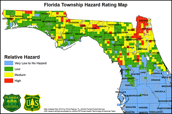
The Southern Pine Beetle Florida Township Hazard Rating Map is based on a model developed by the U.S. Department of Agriculture (USDA) Forest Service's Forest Health Technology Enterprise Team as part of a hazard mapping project for the southeastern United States.
The model computes hazard scores based on input variables that estimate the density and basal area of the most susceptible host pine species (e.g., loblolly and shortleaf pine) and soil drainage characteristics. Each township score represents an average for the forested areas within the township.
The hazard map is subject to change from year to year with changing forest conditions and improvements made to the hazard model. Hazard is an estimate of where southern pine beetle infestations may be likely to develop based on forest conditions; it does not mean that southern pine beetle infestations are predicted for a certain area in a given year.
Southern Pine Beetle (SPB) Hazard Rating Definitions
- High Hazard: Areas where current forest conditions are exceptionally conducive to chronic SPB activity and/or an area-wide SPB epidemic at virtually any time.
- Moderate Hazard: Areas where current forest conditions may periodically harbor SPB activity and occasionally incur and sustain relatively numerous, enlarging and/or widespread SPB activity that has a moderate potential of attaining outbreak proportions.
- Low Hazard: Areas where current forest conditions are capable of sustaining some scattered infrequent or otherwise local/limited occurrences of SPB, and there is little chance of an area-wide outbreak.
- No Hazard (i.e., none): Areas where there is currently virtually no known potential for any SPB activity.
Learn more about the Southern Pine Beetle Hazard Mapping Project by visiting the USDA Forest Service website.


